Monday, December 11, 2006

Evidence of an Ask.com mapping API?

Along with a lot of other people, we've been anxiously awaiting any news about an Ask.com mapping API. Why? Because Ask.com provides much better satellite imagery than Google. Check it out yourself. We REALLY want that on MyOutdoors.net.

So, what makes us think there's an API on the way? Well, IAC/InterActiveCorp, the ownerof Ask.com, also owns Evite, where the new Ask.com maps are now being used. I just happened to get an evite recently and and pulling up the source from a map on the evite shows us this little beauty:

<script type="text/javascript" 
src
="http://api.syndication.ask.com/maps/maps1.1.js"
<
\script>

Well I did a wget on the file and a little bit of hacking to try to run it off of our local server, just to see if it would work. I got everything running, but no imagery :( I didn't look into it much further since I'm guessing they designed it that way.

Tuesday, November 21, 2006

MyOutdoors.net adds Google Co-op integration!

I've been wanting to do this for quite a while and I finally got around to it. Google Co-op is a great service that allows you to see relevant search results from a specific website right in your Google search results. In this case, if you are subscribed to our links, you will see search results from MyOutdoors.net when you search through Google. For example, I did a search in Google for "hiking," and this is what shows up for the subscribed links:

We added the keywords from the activity type (hiking, biking, etc.) to our RSS feeds so that the top entry will show up. In the future, we'll extend this even further so that you can add your own tags to journal entries and then more searches will end up hitting more entries on the site. We also want to add custom search to MyOutdoors.net so we can provide even more relevant search results to our users.

If you would like to subscribe, click on the button below:


Let us know what you think!

-Dale

Monday, November 20, 2006

Video clip of MyOutdoors.net interview on WKOW

If you want to check out the article and video from our interview with WKOW-TV here in Madison, WI, you can see it at http://www.wkowtv.com/index.php/news/story/p/pkid/25350.

Wednesday, November 15, 2006

MyOutdoors.net on Television! - WKOW Madison, WI - 10:00 P.M. Sunday, November 18, 2006

Apparently the Isthmus article generated a little more buzz than we thought. We were pretty surprised when WKOW asked us for an interview. I don't think I've personally been interviewed on TV before. Hopefully I don't acti like a fool...

Anyway, to all you Madisonians, watch us on TV! 10:00 P.M. Sunday, November 18, 2006 on WKOW, the local ABC station.

Thursday, November 09, 2006

Oh, how we love the Isthmus!

We were recently fortunate enough to have David Medaris of the Isthmus interview us here at MyOutdoors.net. It's the first real publicity the site has received so we're incredibly excited about it. David wrote a fantastic article and really made an effort in describing what we're all about. Go check it out.

Thanks, David!

Thursday, October 26, 2006

Search for journal entries by location!

Continuing our quest to implement the most fully featured community mapping site available, we just completed location-based searching of journal entries on MyOutdoors.net. This feature integrates into the site extremely well, with lots of different options for finding journal entries.

To start, there is now a link at the bottom of every journal entry that says "Find nearby journal entries." It's right next to the distance field and looks like this:

The link will take you to the location search page to display all of the journal entries that are close by. It currently uses a default search radius of 150 miles (apologies to all you metric folks out there). It's kind a wide range, but we thought that you would want to see something rather than nothing, and for journal entries out in the middle of nowhere, it could be useful. Also, they're sorted by distance so the closest ones show up first. Once you're on the search page, you can change the search radius, or enter new search criteria.

Search criteria can be anything that Google can geocode, including cities, states, zip codes, etc. You can even enter a longitude and latitude. One of the cool things about it is that if you could link to the location page directly, passing in three parameters in the querystring. Just use http://www.myoutdoors.net/location.php? The parameters are:

lat (in degrees)
lng (in degrees)
distance

And then you can see all the journal entries that took place nearby.

There is also a new Location-based Search box on the Browse page. This is the entry to the location search for other search criteria.

Enjoy!

Tuesday, October 17, 2006

KML Downloads


We recently added KML downloads to MyOutdoors.net. I didn't realize how cool they were until I started implementing them. The KML specification has matured over time and is now at a 2.0 release. KML stands for Keyhole Markup Language, an acronym that endured Google's acquisition of Keyhole in 2004. The KML specs allow for some serious mapping annotations. Some of the cooler things are 3d paths, polygons, HTML annotations, custom overlays (ground and screen) and serving content from remote locations. Really the best thing about KML though is that you can put your own data into Google Earth's amazing 3d interface.

We've really only touched the surface with our KML implementation. As we have the time we'll try to add some of the more advanced features of KML. Downloading KML from MyOutdoors.net will get you a KML document that has your path and a placemark for every waypoint in your journal entry that has been annotated. The view should then be centered at the normal centering point for the journal and the camera tilted at a 45 degree angle. Seeing a path set atop the 3d terrain with satellite images gives you a very good idea of what the author's journey was really like.


I hope you all enjoy the new feature. Look for some enhancements to KML files on MyOutdoors.net in the near future.

Thursday, October 12, 2006

Run for the Rivers 5/10K!

We recently posted a new race map for the Run for the Rivers 5/10K in Verona, WI. As always, we're happy to have the opportunity to help out local races and I think this should be a pretty fun one. Also, proceeds benefit the River Alliance of Wisconsin, a non-profit, non-partisan organization working since 1993 to protect, enhance and restore Wisconsin’s rivers and watersheds. Being a flyfisherman myself, I think this is a great cause, especially due to recent events here in Wisconsin such as the Black Earth fish kill in 2001.

Check out the 5K Race map here.
Check out the 10K race map here.
And check out the original website here.

Wednesday, October 11, 2006

Sparklines: display 10K data points in one-half of a square inch

Digg!
Last week I was able to attend Edward Tufte's course in Chicago about Data and Information visualization. ET is out promoting his new book, Beautiful Evidence. A lot of my prior experience is in visualization so I found a lot of what he had to say really interesting. Having been working on the new relaunch of MyOutdoors.net, I really took an interest in one particular topic, Sparklines.

Sparklines are a visual way of displaying thousands of data points in a really small space. A typical example of their use is to display stock trends over long periods of time. Because we implemented elevation profiles in the new site redesign this was a perfect match for displaying a small elevation profile for each of our individual journal entries. For an example of the way we use it, check out http://myoutdoors.net/entry.php?id=2039. It's a hike that my brother Brian did across three different peaks in Wyoming. The sparkline is displayed in the lower-right corner of the page, right next to a link to see a larger graph of the elevation data. It shows the general elevation of the profile in great detail, in about one-half of a square inch. You can click on the elevation link to see what our implementation looks like as well. Here's what it looks like:


We used the Sparkline PHP library to implement the sparklines. It was incredibly easy and we recommend it to anyone. One thing that I didn't like, however, was that it seemed to work primarily for integer indices on the x-axis (I couldn't figure it out anyway if it was supposed to work with floats). Because we graph elevation along the route of a journal entry, we needed to interpolate the distances between waypoints.

Note that we could have just mapped the distance at each waypoint to an integer index in the image. However, a lot of our journal entries have way more than 100 waypoints because they come straight from GPX data (the width of the sparkline is 100 pixels). Because the Sparkline PHP library uses gd, we didn't want to be drawing lines on the server for each set of two waypoints (when you use RenderResampled in the sparkline library, it creates a larger image and scales it down for anti-aliasing, so this could get really time consuming). We want to display sparklines for every journal entry, so with a lot of people on the site, they could cause some potential performance issues (no idea if that will actually work).

So anyway, if you want to create sparklines and you have a ton of data points, doing something along these lines might help your performance if you have a ton of traffic to your site (I never really measured, it just seemed like this would be faster than drawing lines in software due to the actual line drawing and probably the memory access pattern). It's not very difficult, but we thought we'd provide the code here in case anyone has similar needs:

Notes:

$distance is an array of float-valued distances from the start to each waypoint
$elevation is an array of float-valued elevations at each waypoint
$width is the width in pixels of the sparkline, we use a size of 100x20


// For each pixel in the sparkline, compute the elevation at that pixel.

for ($i=0; $i<$width; $i++) {
    $cur_dist = ($i / $width) * $total_dist;

    // Advance the index into our distance array.
    // This determines which waypoint we're between.
    while ($cur_dist > $distance[$dist_index+1]) {
        $dist_index++;
    }

    // Compute distance along this interpolation interval
    $val = ($cur_dist - $distance[$dist_index]) /
        ($distance[$dist_index+1] - $distance[$dist_index]);

    // Inpolate the elevation at the pixel location
    $elev = $elevation[$dist_index] +
        ($val * ($elevation[$dist_index+1] - $elevation[$dist_index]));

    $sparkline->SetData($i, $elev);
}

$sparkline->SetFeaturePoint(($min_dist / $total_dist) * $width, $min+1, "red", 3);
$sparkline->SetFeaturePoint(($max_dist / $total_dist) * $width, $max-1, "green", 3);
$sparkline->SetFeaturePoint(0, $elevation[0], "gray", 3);
$sparkline->SetFeaturePoint($width-1, $elevation[$rows-1], "gray", 3);

$sparkline->SetLineSize(4);
$sparkline->RenderResampled($width, $height);
$sparkline->Output();

Sunday, October 08, 2006

Lessons in Web 2.0 Design – MyOutdoors.net

Digg!


Well we're finally finished with the MyOutdoors.net redesign and both of us are really happy with it. Things turned out better than we expected, we're especially happy with a much smoother user experience than we previously had. We spent a lot of time on the actual design, eliminating the unnecessary parts of the site and emphasizing the important ones. In the end, there were a lot of things that we learned about designing a site for a community. In this post, we'll try to share our experiences with everyone.


There is one point in particular that trumps all of the others: It's not just about the idea. We had a pretty good idea. We had no traffic. We might have been Web 1.5.


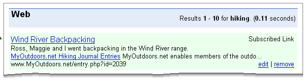
We think that MyOutdoors.net is different from the other mapping sites we know of because it lets you create a journal of your outdoor activities, including custom HTML layout. A lot of mashups like gmaps-pedometer only let you create a map. MyOutdoors.net also has a much wider audience than others. There are some travel sites out there that do similar things too, but they're very travel oriented and, well, we like the outdoors. There just isn't anything quite like it. We at least thought that we had a good idea.

It turns out that implementation and design are pretty important as well. Together, these two things are what killed our site. The old implementation made it possible for a user to create a journal entry and share it with people; we at least accomplished that much. There were lots of problems though. It wasn't easy to create a map because you had to create a user first. If the map had too many waypoints things got slow. The site didn't look good on smaller displays. Browsing journal entries was difficult. The list goes on... We learned a lot from the first implementation of the site. We had some great feedback from friends and a lot of the bloggers we contacted. Here are five more lessons that you might want to think about for your Web 2.0 site:

K.I.S.S.

Keep it Simple, Smartypants. Google should have taught us this much. You see it everywhere. “But we have so much to show them,” I argued. My brother (Brian that is, I'm Dale) said there was too much going on. He was right. I wanted to display the top journal entries, the recent journal entries, the watch list, a blurb about the site, the comments, and I wanted a pretty header to cap it all off. I thought I could do it all. It was just too much. This brings me to the next point:

Popularity is King.

It's true. You wanted to be on prom court, don't deny it. You also want your blog entry on Digg's front page, you want Alexa rankings, and you want Technorati recognition. Hopefully, you'll also want your journal entry in our Top 10. So that's all we put on the front page, plus a button or two to easily navigate the top journal entries. We also stuck some advertising in there; we want to make some money after all.

Focus on Content

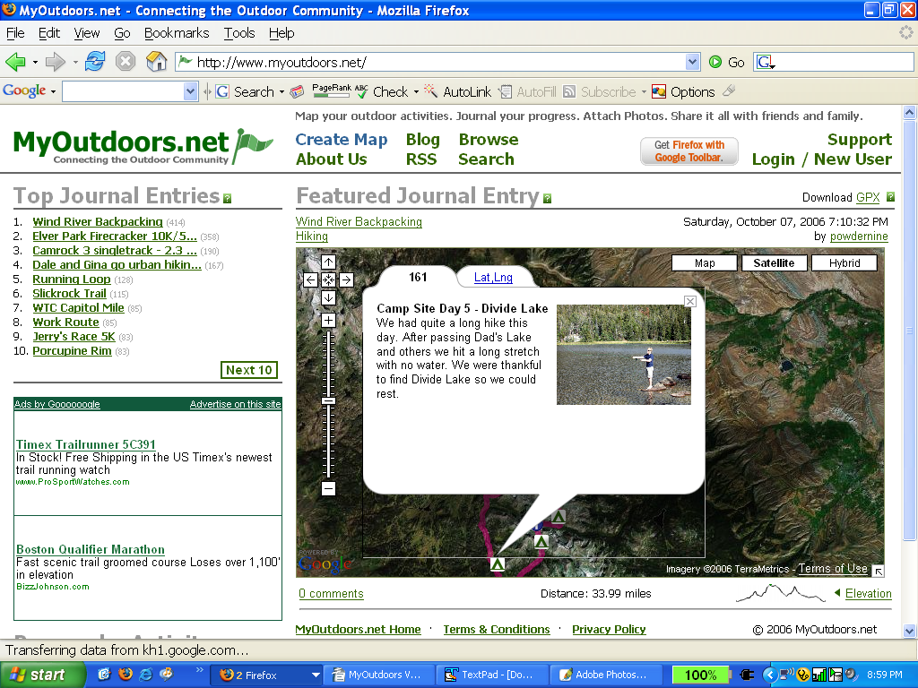
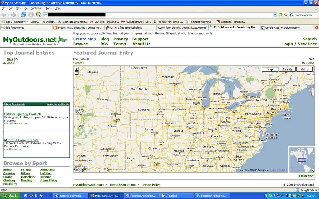
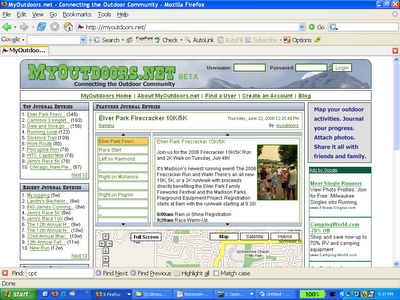
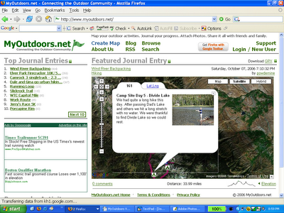
The map is the most important thing, but where was it? You could barely see anything. And if you could, you couldn't see anything else. There just isn't enough room to put everything and our site probably looks like some other mapping mashups now because of it. We had to maximize the area used for content so we shrunk our logo and moved things out to secondary pages that didn't need to be on the front page. There's also a separate page for the journal entry where you can see everything now. Check out Version 1 versus Version 2 below (please excuse the formatting, we're having issues with Blogger...). You'll see that nothing looks the way it used to.


Version 1
Version 2

Make it Easy

We made an attempt to do this the first time, but we failed pretty miserably. The biggest change we made was so that someone could play around with the site without creating an account. Now, there's a big link sticking out on every page that says “Create a Map.” Our hope is that people will see it and play around with the site when they get there.

We also tried to streamline the entire experience, from when a user came to the site to when they created and saved a journal entry. This included the process of actually creating a map. First, we had to make sure a user could get to the location on the map that he or she was looking for. To do this, we added geocoding to find a particular city or address and a navigation mode that lets you double click to zoom in on a particular point. Second, we had to make it easy to add, delete, and insert points so new interaction modes were added for each of these. Lastly, we had to make the account creation process as non-invasive as possible. Now, all we ask for is your email (which we only intend on using for abuse notification), a username, and a password. All of this was important because we had to make it easy for people to use the site, or they came and poked around, were unimpressed, and left.

Don't Forget Engineering

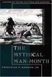
Web 2.0 still needs software engineering. For you geeks out there, I'll refer you to Dr. Brooks' collection of essays called The Mythical Man Month. There are two very important essays that apply here: Plan to Throw One Away” and The Second System Effect. I think that they go together very well. “Plan to Throw One Away” basically says that the first implementation is always wrong; you need to throw it away and start over. “The Second System Effect” says that the second system an engineer designs is always the most dangerous due to over-engineering. We really wanted to add some more things to the site but we tried to hold back and do this release correctly. The result is a ground-up rewrite including only those features that we thought we needed to include to make the site successful (for example, we took out the watch list, we'll add it back in when we figure out the best place for it). By the way, every essay in the book is worth reading.

There's also a mantra out there about reinventing the wheel. We tried to do a bunch of that originally as well. We wrote our own dialog class for example. There was a lot that we shouldn't have tried to do. The new version of MyOutdoors.net uses the Yahoo UI library. It's really easy so don't try doing it all yourself.

Conclusion

I'm sure there are other things that deserve to be mentioned about designing for Web 2.0. I'm not going to claim that this is it but those are the things that we thought were really interesting when we went back and looked at what went wrong. I think everyone should think about how Web 2.0 really is different though. I don't think it's just another fad. I see Web 2.0 as the re-integration of the community into technology. In the beginning, the construction of the Internet was the creation of a community. As it progressed, a lot of that was lost and I see Web 2.0 as regaining something that has long been forgotten. I hope that the current trend in big business grasping at every community site out there doesn't lose that along the way. That's just my opinion though.

Anyway, we really hope you like the new site. If you have any suggestions, please let us know and we'll do everything we can to incorporate them (in a reasonable way :) ).

Thursday, September 14, 2006

Complete MyOutdoors.net redesign coming soon, including elevation profiles and full text search

In the words of the immortal Rakim, "it's been a long time." We're deep into a complete, ground-up, redesign of MyOutdoors.net including a lot of new features. The redesign's sole purpose is making the site more intuitive and usable. The end result is going to be a much bigger map, easier navigation, including for lower resolution displays, and a lot less information overload, plus a lot of new features. Best of all, you can create maps and play around with the editor before creating a user. Here's a quick screenshot of the new homepage:

There are a few things that aren't showing up right now, such as the comments below the map, and a link to view the elevation profile. There is also navigation in the top journal entries section that allows you to browse the most popular journals without leaving the page. One nice thing about the elevation profile is it's going to be an actual image generated using gd instead of something using javascript or flash so you can download it and use it for whatever you want (and yes, for the more savvy users you could take a screenshot using the other methods as well. We're hoping this will make things a little more usable for the masses). I'm hoping there won't be problems with server load due to the elevation profile if the site ever gets popular though...

There were some big issues with the old site that have been fixed as well, including editing of maps with over 60 or so waypoints. That should all be taken care of now. There will also be a bunch of different kinds of map markers such as invisible ones, camping sites, information markers, and warning markers, as well as the original flags.

We've also added GPX uploading to the site. My brother has a great map of a 35 mile hike he took in Wyoming. The elevation profile looks fantastic, showing 3 well defined peaks. There are a few blips in the elevation data from his GPS unit, but overall it's pretty impressive.

The last big thing we're adding is full text search so you can find anything in the title, description, or comments for the journal entries. This will then be integrated into Google Co-op so you can see MyOutdoors.net search results in your browser. I've been wanting to do that for a while :)

I think that's about it. It's basically going to be a completely new site. Check back soon to see it, hopefully we'll have it up by October.

Tuesday, July 11, 2006

UW-Madison Running Club's 13th Annual Fall 15K!

We just added a course map for the UW-Madison Running Club's 13th Annual Fall 15K Run. This is the only 15k in town and can also be run as a 3x5k relay. This race is at the beatiful Warner Park and is taking place on October 22, so the leaves should be just about at peak color. Enjoy the race!

Thursday, June 29, 2006

2006 WTC Capitol Mile!

We recently put up the course layout for the 2006 Wisconsin Track Club Capitol Mile on MyOutdoors.net. This is another local race in Madison, WI, taking place on Sunday July 23rd. The race takes place at the beautiful capitol building and should be a really fun event.

Thursday, June 22, 2006

Elver Park Firecracker Run!

MyOutdoors.net is working with KMR Media Partners to help promote the Elver Park Firecracker 10K/5K run here in Madison, WI. A portion of the proceeds from the run goes towards the Madison Parks Playground Equipment project. Elver park is actually really close to where we live, maybe a mile and a half, so we're pretty excited that we have an opportunity to apply the work that we've done for the site to benefit the community.

Happy running, and look for our fliers in your gift bags!

Tuesday, June 20, 2006

Sitemaps and MyOutdoors.net

Recently after we put up MyOutdoors.net I started playing around with Google Sitemaps. The service basically allows you to create a sitemap of your site that can be downloaded by search engines for help in indexing the site. I recently posted to the google-sitemaps group about some of my experiences with it because I've seen some oddities. The strangest thing that I've seen is that sometimes the date that the Sitemaps site lists as having last indexed MyOutdoors.net has actually gone back in time, from the 14th of June to the 7th.

The response from someone in the community said that others have seen similar behavior. The strangest thing is that the Sitemap on the site states that pages are updated daily. Since the site is designed for journaling outdoor activities, this seems reasonable, but it doesn't seem to be happening. Another oddity was that there were HTTP errors (because we took down the forum) as recently as the 16th, and the sitemap was downloaded as recently as yesterday, the 19th.

All of this wouldn't be a big deal until we get some content up, but eventually I want to incorporate Google Co-op so that searches in Google can return results from MyOutdoors.net directly in your search results. This can only happen if Google is indexing the site often enough for things to be up-to-date.

Stay tuned, and maybe soon we'll have full text search and Google Co-op integration.

Monday, June 19, 2006

New Header and Logo

We're starting to play around with the header on MyOutdoors.net and trying to get something a little better up there. We've been using iStockPhoto to try to find some decent images for the site, with marginal success. I haven't spent too much time on it yet, maybe I'll have some more time in the next few days. The one that's up there is decent but I'd like to get something better.

It was also a pain to manipulate the logo, username and password to go along with the image and get everything to a point where it was visible. You still can't see the login stuff too well, but I'm not sure how long we'll stay with that image so I'm not going to muck with it too much more. Oh, we also changed the logo to take out the texture so it's a little more readable. I've complained that it looks a bit plain now but not everyone agrees with me :)

Sunday, June 18, 2006

More new additions

We received some much-needed feedback from members of the outdoors blogging community regarding the site and have started to incorporate it as we have time. Of most relevance is the addition of a small bit of text to the homepage of myoutdoors.net that actually describes the site. We've been meaning to do that for a while and just haven't gotten around to it. Thanks goes out to Tom at Two-Heel Drive, Glenn at anygeo.com, and Dylan at cyberhobo.net for their feedback.

There are still a ton of things that we're looking at doing with the site, including geo-RSS feeds (both import to journal entries and actual syndication) and GPX import. Stay tuned for more updates, and of course, please let us know if you have any comments or suggestions.

Saturday, June 17, 2006

MyOutdoors Enhancements

We have been working diligently trying to improve MyOutdoors.net. Here are some of the new features:

  • Pictures! You can now add pictures to your journal. We require you to host your pictures elsewhere but all you need to do is enter in the url to your pictures.
  • Full Screen View - You'll notice a new Full Screen button on the map, click this to be taken to the full screen page.
  • Publishing Journals - Now when you create a new journal it is not automatically available to the world. You decide when to make your journal public by clicking the "Publish" button in the Journal Editor.
  • Map Types - Google Maps supports Satellite maps, Street maps and Hybrid maps. Whatever map type you are using when you click "Save Journal" will be saved with your journal entry your journal will be displayed using the new map type from then on.
Some features we are currently working on:
  • GPX file upload/download - We will soon support uploading of GPX files you create with your GPS unit. This means no more clicking on the map to create waypoints! We will also offer a GPX file download for all journals.
  • KML file upload/download - KML files are used to import into Google Earth. We hope to offer this capability soon.
  • Geocoding - many of you have probably noticed that there is no way to search for an address on our site. Well Google finally came around an is offering this functionality in their API so we will be adding it to the site soon.
  • Bug Fixes - We know they're out there. We're trying.
Please keep sending us feedback on the site. Your feedback is extremely helpful to us and we try to incoporate as many of your ideas as we can. Thanks so much for your help!

Thats all for now, Happy Mapping!